How Rakshaks Are Improving a High-Risk 270-Metre Stretch in Varanasi
Team WorkWizards audited the Gurubagh–Bhelupur corridor — a short stretch with an outsized crash footprint — and proposed interventions a ward engineer can deliver.
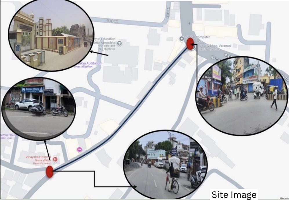
A road that never rests
Some roads announce their danger loudly — with wrecked vehicles, sirens and headlines. Others are quieter. They carry risk in everyday moments: a hurried step back from traffic, a child tugged closer by the hand, a rider braking just in time. The Gurubagh–Bhelupur stretch in Varanasi is one such road.
This stretch sits at the intersection of daily life. Vinayak Hospital stands nearby. So does the Faculty of Education at BHU. Students hurry through it, patients and caregivers cross it, shopkeepers open and close shutters, rickshaws idle, and commuters cut through — hour after hour, day after day. Traffic flows in from multiple directions, especially at a Y-shaped junction where vehicles merge without clear guidance.
What the records revealed
When Team WorkWizards, led by Anurag Prakash (IIT-BHU), examined police FIR data, the unease felt on the street found confirmation on paper. Between September 2024 and March 2025, multiple serious crashes were officially recorded on this short stretch. The victims were mostly pedestrians and two-wheeler riders. The locations clustered around the junction. The causes repeated themselves: overspeeding, poor visibility and the absence of safe crossing points.
“This wasn't chance. It was a pattern hiding in plain sight.”
Listening to the street
Numbers alone don't capture fear. The team spoke to students, residents, shopkeepers, rickshaw drivers, pedestrians and traffic police. The message was strikingly consistent: speed was the biggest concern. Crossing near the hospital or educational buildings felt risky, especially during peak hours. Blind spots, unclear junction geometry and the constant need to "guess" what drivers might do next were named repeatedly.
What the audit revealed
A detailed road safety audit tied everything together. Despite heavy pedestrian movement, there were no designated crossings. Warning and regulatory signs were sparse or absent. The Y-junction geometry created blind spots that reduced reaction time. Vehicle speeds were incompatible with what is, in reality, a hospital and education zone. The conclusion was hard to ignore: this road was routinely placing people in avoidable danger.
- No footpath continuityPedestrians spill onto the carriageway every 30–40 metres.
- Blind exitsSide lanes meet the corridor with zero advance visibility.
- Mixed vehicle speedsE-rickshaws at 15 km/h share lane with two-wheelers at 50 km/h.
- No safe crossingsHospital and school users cross between parked vehicles.
Small changes, big difference
Grounded in crash data, audit findings and community input, the team proposed simple, proven interventions:
- Speed breakers & rumble stripsPlaced before conflict points to cap free-running speed.
- Convex mirrorsAt every blind exit to address junction blind spots.
- Reflective signageClear markers for speed limits and nearby hospital and school zones.
- Continuous footpathRe-cast the footpath with bollards and zero gaps.
- LightingPole-mounted LEDs covering the full stretch.
- Pedestrian crossingsMarked, illuminated crossings near hospital and BHU access points.
“No grand redesign. No expensive technology. Just basic road safety tools, used where they matter most.”
From findings to action
Once the team confirmed that the stretch fell under Nagar Nigam jurisdiction, they took their findings to the relevant authorities. What helped move things forward was the proposal's clarity — a clear link between data, everyday experience on the street, and realistic, low-cost solutions. With risks clearly articulated and interventions well within administrative feasibility, the recommendations received approval, marking a crucial step from analysis to on-ground action.
“We have been writing letters for years. This time someone walked the road with us and wrote it down properly.”
Why this matters
The Work Wizards and the CFI team will keep following up until these changes are no longer just plans on paper, but real protections on the road. Through Project Rakshak, every high-risk section is studied, every danger mapped, and every solution designed with evidence and local insight. Success isn't measured in reports — it's measured in streets made safer, in lives protected before accidents happen. This 270-metre stretch will still connect Gurubagh to Bhelupur, but now it will demand nothing from its users but safe passage.
Short stretches, big wins
Most Indian black spots are shorter than 500m. Audit one. Fix it. Repeat.
Share this story
A youth-led road safety audit and intervention plan for a 270-metre Varanasi corridor.